|
|
|
|
(delwedd 9940) (09 Ionawr 1909)
|
Rhondda Leader. 09
Ionawr 1909.
Welsh Topics.
Rhondda Place-Names.
WHAT "RHONDDA" MEANS.
Oftentimes do we hear, “Why is the Valley called Rhondda?” It is not a word
which is easy of solution, and some attempts at explanations are so silly as
they are ingenious. The word probably - and we say probably advisedly — means
“the good river," and is composed of the Old Welsh word, “hon,"
meaning river, and “da," good. The name may be found in a few
place-names, as Afon, Cynon, Aberhonddu, and Honfel. The “r” of the word is
derived from the article “yr” which precedes it, and which has become to-day
“Y Rhondda," instead of the old probable form, “Yr Hondda."
Professor Anwyl, writing in the “Celtic Review” for January, 1908, in his
article on “Wales and the Britons of the North," mentions the name of a
river “Anhon," which is found in the Gododin, the oldest Welsh poem. He
says: “Probably ‘ynhon’ is the name of a river." To trace the word back
to a further source we have not succeeded, but sooner or later the mystery
will be solved.
The difficulty of finding the correct equivalent is rendered still harder by
the later spelling of the word. The Valley is rarely called by its single
name, “Rhondda," but by the compound, “Glynrhondda”, the Vale of the
Rhondda. Here are a few of the forms found in old Welsh books: — Glynrhodneu,
Glyn. Rhoddni (footnote: Rhoddnei, Rhoddne). Glynrhoddni, and Glyn Rhodni. In
other works there are Glinrothoni (dated 1314), Glinrothne (1326), and even
Glenrotheneye, and Glynrotheney. That there are so many forms is due to the
crass ignorance of English clerks who knew nothing regarding the spelling of
Welsh names.
It will be noticed that in all these varied forms, the “d,"
"dd," or "th" always precedes the “n" (cf. Aber
Hodni). This is a very common practice with certain words which have “n"
in the last syllable, as may be seen from the word "ofni," which
becomes in the Gwentian speech "onfi." It is a common thing to
transpose two such sounds, and thus we have the negative evidence that the
correct form is "Rhondda," and not "Rhoddni" or any akin
form.
I.-VILLAGES. 1. Blaenrhondda, Blaen'cwm. "Blaen" means the farthest
part of the country, or the place nearest the source of the stream or river.
Blaenrhondda thus means the source of the Rhondda River. It gives its name
also to a farm and village near at hand.
Blaencwm formerly was the district now known mainly as Tynewydd, as may be
seen from the fact that the Baptist chapel in Tynewydd is still in Blaencwm.
Cwm, combe, or cum means a hollow or dale.
2. Tynewydd derives its name from Tynewydd Farm, situated behind Tynewydd
House, the residence of Alderman W. Morgan, J.P. The farm forms one of a
series built at the same time some centuries back — Tynewydd, Tydraw, Y
Maendy, &c.
3. Treherbert (Tre and Herbert), so named in 1851 after a member of the Bute
family.
4. Penyrenglyn, or more correctly “pen eneu'r glyn," the head of the
opening to Glyn Rhondda. Eneu’rglyn would become by transposing the first two
syllables - a common thing in place-names — “yrenglyn." Pen was affixed
to make it consonant with other pens in the district, such as Penpych and
Penbilhwcan. Can any reader suggesf any other solution?
5. Treorci, Treorky, or Treorchy. This place-name means “the village on the
river ‘Gorci.'” There are two plausible solutions as to the meaning of the
form “gorci." Some will have it that the true name should be
"Treorchwy," and, therefore, Abergorchwy. Now, the latter supplies
the key to one solution that “gorci” is the Anglicised form of
"gorchwy." “Gorch” means rim, limit, or boundary, and therefore, an
enclosure.
The other explanation is that “gorc” is the pre-Norman form of the word which
has survived. It is readily granted that there is a wonderful tenacity in
place-names for old forms, and that the true form" gorci" is found
in the present word, "Abergorci." It is very likely that the stream
“Gorci" formed an ancient boundary. (To be continued).
|
|
|
|
|
(delwedd 9938) (16 Ionawr 1909)
|
Rhondda Leader- 16 Ionawr 1909.
Welsh Topics.
Rhondda Place-Names.
I. - VILLAGES.
6. Cwmparc; the valley of the parc, a word which means an enclosed piece of
ground. Parc, the Welsh form of the English word park, is a, word common to
both the Teutonic and Celtic tongues. It is one of the words found in
Glamorgan due to the Norman influence. A farmer well acquainted with this
spot once informed me that he well remembered such an enclosure in this date.
The village name is thus clearly derived from this little plot which was
walled in. It was once thought that the word parc was only common to
Carmarthen and Pembroke, where it means a field; but its presence in this
valley gives denial to that fact. There are two farms which bear the name
parc — Parc Isha and Parc Ucha.
7. Ystrad means a flat valley, or low-lying country beside a river. It bears
the same meaning as strath (cf. Strathmore, in Scotland). The word has no
connection, as is sometimes thought, with the Latin strata, a paved way; but
is rather derived from a Celtic word meaning first the river in the valley,
and secondly the land beside the river. The name is also, found in
Ystradyfodwg, Ystradfechan, and Ystrad Ffyrnol (or, as written, Ystrad
Ffernol). Ystrad was once applied to the whole Valley, as may be seen from
the fact that the Valley was called Cwm yr Ystrad, and the inhabitants “Gwyr
yr Ystrad."
8. Pentre, a compound word formed from pen, meaning chief or first, and tre,
tref meaning a village or township. Needless to say that this is a very
common place-name in Wales. First given to a farm, then to the few homesteads
near by, and now to the district around. Pentre contains the oldest
dwelling-places of the Rhondda, for formerly it was known as Pentre'r Ystrad.
It must not be thought, though, that this is the only Pentre in the Valley;
there is Pentre Agil, Pentre Cegil, and a Pentre above Penygraig.
9. Gelli or Gelly. A very common place-name in Wales, signifying a grove or
bower. Cr. Gelliwen, Gelliwastad, Tref y Gelli. Gelliwig, and in the Rhondda
itself Gellifaliog or Gellifaelog, and Gelligaled. It was variously spelt by
the Norman-Frenfh. e.g. Kethly, Kelle, Kolli, and by the Welsh scribes"
Celli," as may be seen from Pencelli and Celiigaer." The presence
of the K has caused some critic's to believe that the true form should be
Celli," and thus connect it with cell," meaning a sanctuary or a
place of worship. This is done to please nreconceived notions regarding the
name, and thus they are contorted to suit the fancies of the writers.
10. Bodringallt. Here is a word which has puzzled many who have attempted to
solve it. Many reasons have been given for the explanations advanced, but so
far very unsatisfactory. "Bod" is easily explained as a
dwelling-place or residence. The difficulty lies with “ringallt." Here
are a few of the solutions: - (1) Bod-rhwng-dwy-allt, i.e., a dwelling-place
between two copses of wood. This cannot
|
|
|
|
|
(delwedd 9939) (16 Ionawr 1909)
|
be accepted, for at one time the whole of the Rhondda was one extensive
wooded glen. (2) That "ringallt" is a corrupted form of
"rhingyll," and that the true and only way of spelling it is
Bodrhingyll," in honour of Cadwgan the Battle-Axe, who is said to have
lived there. This, too, must be refused, as by no possible means can
“ringallt" he derived from "rhyngyll." (3) Another author
explains it as “Bod-reynallt (sic) i.e., the fox's abode, because the Valley
was noted for the haunts of Reynard. Like the second, there is no phonetic
reason given at all.
If these place-names are to be satisfactorily
solved, then the rules regarding sounds and changes must be fully recognised.
We believe that the proper meaning is “Bod-Reinallt," the abode of
Reinallt. But who was Reinallt? He was a bard of the sixteenth century who
lived in this Valley. We learn that he was present at a gathering of the
bards held on Craig y Dinas. His name appears last on the list, and it is
conjectured that he was the secretary of the movement, which accounts for his
placing his own name last. There were present: — Dafydd Benwyn, Shon Morys
Lwyd, Dafydd Llwyd Matthew, Llywelyn Shon Llangewydd. Antoni Powel the
historian, Gronwy William, Morgan Powel, and Harri Reinallt.
But here is the difficulty. The place-name
to-day is "Ringallt," as in “Bodringallt and “Nant Ringallt,"
while the person's name is "Reinallt." There are two things to be
accounted for; first, how came “ei” into “i," and secondly, whence came
the "g" in "ringallt." As to the first, it is well known
that in the dialect of Glamorgan an “ei” of the first syllable in dissyllabic
words becomes "i," as eira is now îra, peidio is pido, gwreiddiau
is gwridda, &c. Regarding the “g," one finds it a common thing to
find it inserted after “n," as prin becomes pring (scarce), Lladin is
Llading, and mwswn is now mwswng, &c. Those two reasons dispose of the
“ei” and the presence of the “g." The "steps towards the formation
of the present form would be thus: — (1) Bod-Reinallt, (2) Bod-Rinallt, (3)
Bod-Ringallt. The site of the old house is the present residence of
Councillor Thomas Thomas.
Next article, Place-names of Mid-Rhondda.
Books to be reviewed, and accounts of Welsh movements and societies should be
addressed: “Welsh Editor, c/o 'Rhondda Leader,' Tonypandy."
|
|
|
|
|
(delwedd 9936) (30 Ionawr 1909)
|
Rhondda Leader. 30 Ionawr 1909.
Welsh Topics.
Place-names of Mid-Rhondda.
I. — VILLAGES (continued;).
11. Pont-Rhondda, i.e., the Rhondda Bridge. The village which now bears this
name derived it from the farmhouse near by, which, again, took the name from
the bridge which crosses the river Rhondda. at this spot. It was at one time
the main bridge of the Valley, and was erected somewhere about 1780 by Wm.
Edwards, the famous bridge builder of Pontypridd. Edwards built many famous
bridges in Glamorgan, such as Pontypridd, Pbntycymer, and Pont Treforis.
12. Llwyn-y-pia. Llwyn, a grove., a bush, a clump of trees, and pia, a
magpie, so that this place-name means the magpie's grove. In the year 1801,
Malkin visited this place, and mentions that near the old Llwynypia Farm he
saw the largest oak he had ever seen. Llwyn is very common Welsh place-names,
as Llwynypiod, Llwyndu, Crynllwyn, Llwyn Onn.
13. Cwmclydach, i.e., cwm, a vale, dale or valley; clyd, sheltered; and aeh,
a I river. The name means the vale of the sheltered river.
Cwm — a hollow, a dell, a bottom a deep valley where the sides come together
in a concave form, whereas the sides of a glyn approach in a convex form a
valley or dingle opening downwards, and closed at the upper end, which is
generally called blaenycwm." — Silvan Evans' Dictionary.
Cwm is general enough in Wales, and there is no need to quote instance. The
word is also found, now fossilised, in many place-names, proving that these
places were the habitations of the Celts. It constantly recurs as
“combe," pronounced like the Welsh "cwm." but with the long
vowel, thus giving cw*m, or coom or coombe, as for instance, Ilfracombe,
Combe, Comb Martin, Thorncombe, High Combe, Melcombe Regis, &e.
Anderson, the Cumberland poet, writing of his native county, which is supposed
to abound with more cwms than any other county in the Kingdom, says:
"There’s Cwmerhitton, Cwmwhitton,
Cwmranton,
Cwmrangan, Cwmrew, and Cwmcatch;
And many more Coms i' the County,
But nin evir Cwmdoock can match."
Now, the folks of Cwmclydach, and as for that the Rhondda, are very apt to
forget their Cwm, and must needs say "Clydach Vale" - a mongrel
form, which is considered more respectable, and which, perforce, Die Shon
Dafydd must use as well. Let them adhere to Cwmclydach.
Cwmcydach, in the Rhondda dialect, becomes Cwmclitach, but in the Swansea
Valley they say Cwmclydach.
It is a pretty word, and well worth preserving. Clyd means sheltered, protected, retired,
comfortable; and ach is an old Welsh word meaning river. Ach is found in the
names of rivers, as Mawddach, and Clarach. Iolo Morgannwg, however, gives
“ach, a waterline," and “aches, a river." Gweirydd ap Rhys gives
"ach, river," but “clydach, sheltered glade or spot."
14. Ton-y-Pandy. This, word is composed of four parte, ton-y-pan-dy.
Ton is found chiefly in place-names, and
means in the Gwentian dialect a green sward, or grassy plot of ground. It is
found also in the phrase “gwair
ton," green swardy grass, to distinguish it from
|
|
|
|
|
(delwedd 9937) (30 Ionawr 1909)
|
“gwair rhonc," coarse grass, and
"gwair man," mountain grass. The word in place-names may be found
associated with personal names, topographical, local incidents, and farms.
Here are a few place-names containing ton: - Tonypandy, Tonyrefail,
Abertonllwyd, Tondu, Tynton, Ton Ystrad, Tongwynlais, &c. The plural form
is found in "Tonna," near Neath.
Ton is variously derived. First, that is the Anglo-Saxon form of tun, a
fence, farm, town. This would give in Welsh tyn, which is found in
“tyno," a dale, a green plot, as in "Tynohir," a place on the
banks of the Dyfi. (See" Ystyron Enwau," by R. R. Roberts, p. 46).
Also
“Nid oes dwyn na dwys dyno
Yn neutri glynn yn nant y glo."
— Dafydd ap Gwilym.
Secondly, that it is a cognate form of “twnn” (masc.), “tonn” (fem.), broken,
rent, torn. Land broken and laid out would give better crops of grass than
other soils, thus we easily arrive at the idea, of green, rich grass. The
form tyno may thus be a mutated form of “twnn” (masc.).
“Ton” is feminine, for it may be taken as a general rule that monosyllabic
words containing "o" are feminine.
Pandy is pan, from pannu, to full cloth; dy, a house, so that the whole means
a fulling mill, or a fuller's workhouse.
Tonypandy thus means the green sward of the fuller's mill. The old mill is
still standing below the road near the Leader Offices. The “Ton” was the side
stretching from near the Cross Keys on to Nant Clydach. There are many of the
inhabitants who remember when all this patch was covered with “caeau
gleision” (green fields).
Near the mill was a wooden bridge, leading to the road past “Tyrtwyn” on to
the Pandy Inn, and thence to the “Cwrt” — a very interesting place-name,
which we shall touch upon again.
15. Coed-y-meibion is a personal name, and means the sons' wood coed, wood
meibion, a double plural of mab, son. There is nothing to warrant us in
believing that this can be transformed into Coed y Mabinogion.
16. Trealaw. Tre, town; Alaw, the nom-de-plume of D. Williams (Alaw Goch),
the father of the late Judge Gwilym Williams, Miskin Manor, on whose estate
the village is built.
17. Dinas. The name means a hill-fort, or a camp, and is derived from the
Welsh word din, a fort. Cf. Dunedin, Londinum, Uxeledonum in Cumberland,
Dunkeld, Dumbarton, Dunstable, etc. There are historical remains on Craig y
Dinas, the hill overlooking the coal village (Dinas y Glo) as it was known.
18. Pen-y-graig is the head or top of the rock, and is so named after the
farmhouse of that name.
19. William's Town (?). Here is a thoroughbred Saxon. Better would it be to
restore it to the prettier and more euphonic Welsh name, Hendre Gwilym, a
farm in this locality.
Books to be reviewed, and accounts of Welsh movements and societies should be
addressed: “Welsh Editor, c/o 'Rhondda Leader,' Tonypandy."
|
|
|
|
|
(delwedd 9941) (06 Chwefror 1909)
|
Rhondda Leader. 06 Chwefror 1909.
Welsh Topics.
Rhondda Place Names.
I. — VILLAGES (continued).
20. Porth, a gate, entrance. It forms the gateway to the two Rhonddas. The
word is common in Welsh place-names, as Porthcawl, Porthceri, Porth Dinorwic,
Porthaethwy, Aberporth, &c. The word is derived from the Latin porta, a
gate, the “F” [sic; = “T”] of the Latin word giving “th” in Welsh, cf. tortus
giving torth (a loaf).
21. Cymmer, or more correctly Cymmer Glyn Rhondda. The country abounds with
so many cymmerau that a distinctive name is a added to it, as Cymmer Glyn
Corrwg, Pontycymmer, Maesycymmer, Cymmer Cefncoed, &c. Cymmer means the
junction of two waters. The word is formed from "cyd" — with,
together; and “mer” — water. When “cyd” is assimilated to another word
beginning with “d," the “d” is changed into m, so cyd + mer becomes cym
+ mer.
“Mer” is the same as the French “mer,” sea; but in Wales it refers more
distinctively to water which opens out when joining another sheet of water,
and it is in this sense it is applied to “Y Mera," the watery marsh
around Neath. The fishing folk of the Neath district are called “Gwyr y Mera."
The word "mer" is also seen in "Aber"; the "m"
and “b” often interchange. It would be an interesting study to compare the
following: — Latin, mare; French, mer; English, mere; Welsh, Ber, môr; the
Gwentian mera; and the Irish muir.
22. Hafod (now Trehafod) has got its name from a neighbouring farm. The word
is common for places situated on the slopes or the summits of the hills. The
word is derived from "haf” (a summer), and "bod" (a dwelling),
and means a summer residence. Perhaps the more correct form is the compound
“hof-ty." [sic; = “haf-ty”] The dwellings of some families were
duplicated; in the summer they lived in a house on the higher part of their
property, called the havod-dy (literally 'summer-house'), and in the winter
returned to the principal residence (hendref, literally the 'old-stead ') set
up in a more sheltered place." (“The Welsh People," by Rhys and
Jones, p. 248).
23. Ynyshir, ynys, a meadow by the river and partly surroundcd by it; “hir,”
long, thus meaning “long meadow." The village derives its name from a
farmhouse near by. “Ynys" does not mean "island" in the usual
sense. "Ynys"' is quite common inland, as may be seen from the
following in the Rhondda alone: — Ynysfach, Ynyswen, Ynysyfeio, Cilynys,
Ynysgou. We shall deal fuller with Ynys when treating upon place-names
bearing that name.
24. Pontygwaith, i.e., "pont," a bridge; "gwaith," work
or works; so it means the works near the bridge. It is so called. because of
the Iron works erected here in the seventeenth century. It is not known. for
a certainty who erected them, and we cannot do better than quote Nathan Wyn
on the point. “Barna rhai mai Anthony Morley a'i hadeiladodd tua'r flwyddyn
1560. Tuedda ereill i gredu mai tua'r flwyddyn 1788 yr adeiladwyd hi gan
Meistri Meiers, Cwm Nedd... Yr oedd y ffwrnes yn aros mor ddiweddar a’r
flwyddyn 1850."
|
|
|
|
|
(delwedd 9942) (06 Chwefror 1909)
|
25. Tylorstown derives its name from Mr. Louis Tylor,
who opened a colliery here about 1872.
26. Ferndale. Gelwid yr holl gymydogaeth hon yn nyddiau ein mebyd, yn
Blaenllechau. Cfyngir yr enw Blaenllechau er ys blynyddoedd lawer bellach i'r
rhan hyny a berthyn i blwyf Llanwynno. Cofus genym glywed Mr. D. R. Delta
Davies, F.S.A., yn dweyd mai efe roddodd yr enw Ferndale ar y lle. Ond
clywsom wedi hyny, ar awdurdod didroi-yn-ol, mai y diweddar D. Davis, Ysw.,
Blaengwawr, a fathodd yr enw, ac a'i harferodd ar lyfrau y gwaith, heb
ymgynghori dim â neb pwy bynag” (Nathan Wyn in the “Rhondda. Leader,"
24th March, 1900).
Let's leave the newer Saxon form and look at “BlaenIIechau.” As already
explained, "blaen" refers to the point or end of the valley, here
the “Llech," meaning a flagstone. The river flows over layers of flat
stone. “Aberllechau” is the confluence of the “Llech” with the Rhondda Fach.
27. Maerdy, i.e., "maer," chieftain (land agent); and
"dy," house. The “maer” under the old Welsh laws was an officer of
the king's court. There was one in each commote, and his duty was to
cultivate the king's or the chieftain's land, and to superintend the serfs
who worked for the king or chief. The “maer" also presided in the court
of the commote. Rhys and Jones, in the "Welsh People," p. 401, have
a clear passage on this question: — “In each cymwd, or sometimes in each
cantref, there was a tract of land set aside for the chieftain's residence.
It formed an estate which the surveyors very naturally called a manor, and
which in many respects resembled a manor. On this estate was what may be
described as the home farm of the chieftain, called his “maer-dref,"
worked by groups of non-tribesmen or nativi under the management of a land
maer and other officers. The chief also had pasture land allotted to him for
his cattle, and all this he held in severalty."
“Maer” in the Gwentian dialect is now akin to tenant, for the holder of a
farm is still caJIed a "maerwr," and the plural, “maerwyrs," —
the s being foreign. So that in this sense it means the tenant's home or
house, and in that sense one who held his land as a subject of a prince or
chieftain. Taken in its older sense it would mean the chieftain's residence.
During the early part of the eighteenth century it was the home of E. ap
Llewelyn (Evan ap LIywelyn), the author of “Cwn Hela Ystradyfodwg"
(recently given in these columns), and many tribannau.
Books to be reviewed, and accounts of Welsh movements and societies should be
addressed: “The Welsh Correspondent, c/o 'Rhondda Leader,' Tonypandy."
|
|
|
|
|
(delwedd 9933) (13 Mawrth 1909)
|
Rhondda Leader 13
Mawrth 1909
Rhondda Place Names.
Ynysoedd y Rhondda.
Ynys. This word enters largely into Celtic place-names, and possesses a
peculiar tenacity and wide interpretation and wide application. It discloses
to us a phase of the mind of the Celt and the manner he was able to apply a
word to a tract of land similar in character to one which bore the primary
meaning of the word. In its strict physical sense it means “an island" –
a piece of land surrounded by water, as, for instance, Ynys Mon, Ynys Manaw,
Ynys Prydain, Ynys yr la, Ynys Enlli, &c.
When applied to tracts alongside a river it means a quasi-island, or rather,
a flat meadow near a river, or partly surrounded by a river; and it is in
this sense it is generally found in Welsh place-names. Every valley and its
river have their ynysoedd. Occasionally it may mean land along the sea-coast,
as Moel Ynys, Ynys Cynfelyn, Ynys Las; and in the Bible the word is found to
mean a dwelling-place or habitation in contradistinction to waste land,
water, seas and rivers, as the following quotations will show: — “Mi a wnaf y
mynyddoedd a'r bryniau yn ddiffaethwch, a'u holl wellt a wywaf; ac a wnaf yr
afonydd yn ynysoedd, a'r llynnoedd a sychaf" (Esaiah xlii. 15).
"Efe a wareda ynys y diniwed" (tir) (Job xxii: 30). The inhabitants
of Tyrus are dwellers of an "ynys." Cf. Esaiah xxiiii. 2, 3.
Generally speaking, the word “ynys” is a river-meadow, and in the rest of
this article the word meadow will be used alone. In the Rhondda, there are
several of these: — Ynysyfeio or Ynysfeio, Ynyswen, Ynysfach, Cilynys,
Ynysgou, Ynysyfelin, Ynysonos, Ynys Cwmbwll, Ynyshir, Yr Ynys, and Ynysgrig.
The word is equivalent to "inch" in Scotland, as Inchcolm — the
island of St. Columba; inis, innis, or ennis in Ireland, as Enniskillen and
Ennismore (Ynys mawr).
Ynys governs the soft mutation when the following word is an adjective, as: —
Ynys bach — Ynysfach.
Ynys du - Ynysddu.
Ynys llwyd — Ynyslwyd.
Ynys gwen — Ynyswen.
This tells us that it is of the feminine gender (cf., yr ynys hon).
But if the following word is a noun, then it governs the radical, as
Ynystawe, Ynys Môn, Ynys Manaw.
|
|
|
|
|
(delwedd 9934) (13 Mawrth 1909)
|
Ynysoedd y Rhondda.
1. Yr Ynys. The river-meadow
above Dinas Station, and stretching as far as the Naval Colliery. It is now
partly covered by tippings. One of the old Rhondda cross-roads passed
through, leading from Brithweunydd to the houses on the right, which were
reached by a public bridge, known as Pont yr Otin ("the Bridge of the
Limekiln"). There is a street near by still known as “Tai'r Otin."
A little higher up the river was a “gorad” (a weir), which fed the Dinas
Colliery.
2. Ynyswen, the fair or white meadow. This is a long, wide stretch of flat
land situated between Treorchy and Ynysfeio.
3. Ynysfach, the little meadow, situated between Cilynys and Ynysgou. A
Baptist chapel has existed here for many long years. It was long known as
"CapaI Ynysfach," now known as Nebo, Ystrad. The word “fach” is
also found in a near local name — Heolfach (pron. Hewlfach).
4. Cilynys. Nathan Wyn says — "Dau neu dri o anedd-dai bychain ydoedd
Cilynys ddeugain mlynedd yn ol." They were situated near the old tavern
known as ''The Lamb." The old cottages have been taken down since many a
day. We cannot agree, however, that the proper name of this is “Culynys,"
meaning a narrow meadow. The length of the vowel in "Cil" is short,
and this fact debars us from entertaining the notion that it means
“narrow." It is always pronounced short like the English"
kill." It is, therefore, “Cilynys," and not “Culynys."
“Cil” means sheltered or edge, nook, corner. The verbal form is cilio, to
fly, retreat. Other derived forms are ciliad, cilddant, cil-y-llygad.
Another fact which precludes the idea of narrow is that the Gwentian form of
Cul is always pronounced with the long vowel.
The word "Cil" is found in other place names, as Kilybebyll,
Cilgwyn, Cil-y-cwm Cilfynydd (not Culfynydd).
5. Ynysgou, which has been incorrectly rendered as “Ynysgau," which
would mean the enclosed meadow.
"Gou" being an adjective, would resolve itself into its radical
form as cou (mod Welsh cau), meaning hollow." I do not know of a word or
phrase where "cae" or "ca-u" (shut or closed) is
pronounced “cou," but we have the word “cou” or "gou," meaning
hollow.
That "gou" is an old Welsh form can he seen by comparing it with
houl (mod Welsh, haul, sun), cnou (mod Welsh, cnau nuts), dou for dau (two,
clou for clau
|
|
|
|
|
(delwedd 9935) (13 Mawrth 1909)
|
(early). These forms
with "ou" are more correct and older.
6. Ynysfelyn, i.e., ynys y felyn, the meadow of the mill.
7. Ynysyfeio, or Ynys'feio, with the; 'y' suppressed. It is compounded of two
words and "feio." The former is clear in its meaning, but the
difficult portion of it is "feio." It has been explained away to
mean "y beio," for which no sensible reason has been given other
than it has been twisted to suit a historical conjecture. It has nothing to
do with 'beio,' the verb form of 'bai,' and cannot be warranted either on
historical, geographical, or grammatical grounds.
“Feio" is the verb form of the noun "fai," or "mai,"
meaning a field or training ground for soldiers. The dictionarares [sic; =
dictionaries] give “meiwyr," meaning armed men. Resolving this into its
radical form we have 'mai' and the verb 'meio.' But 'm' and 'f' are often
interchangeable, so that "feio" is easily accounted for. The word
'fai' is found in another place name, Penyfai.
So Ynysyfeio would thus mean "the meadow for the training of armed
men." Is there any other name in the immediate locality which supports
this view? I believe there is. Right above Ynisyfeio is an old farm,
"Coedcae'r Arlw'dd," the woodland of the lord of the manor. This
old place was the residence of the old Rhondda lord — Idnerth ap Ifor.
These two old place-names give us an insight into the ancient military
division of the Rhondda. The "arlwad," [sic; = arlwdd] the Gwentian
and Dimetian patois for "Arglwydd," was the lord of the cantref (or
cymwd), and was appointed by the king of the country. He had a set of
officers under him who formed his household. So that regally
"Ynysfeio" and Coedcae'r Arlwdd form the most important part of the
Rhondda. It was very likely the station against many attacks from the Neath
Valley.
8. Ynysgrig is that narrow strip stretching from near Trealaw Station to
"Twyn Bryn Beddau." It is pronounced 'Nysgrig, and sometimes
shortened with "Sgrig." The land on one side rises abruptly and is
very rocky, and leads one to believe that "grig" here mans
"rocky" or "stony," so that the name means the
"rocky or stony meadow.” In support of this is the rock above, which is
known as "Wengrig" or "Y Wengraig" — the white rock. On
the other side of the valley is "Graigddu," the black rock, a very
happy correspondence.
Others explain the place name to mean the "heathery meadow,"
because the ‘ynys’ was covered, wIth ‘heather-bell.' There are many residents
who still remember it so. But these places were baptized in a deeper past
than what comes within the age of present day generations.
9. Ynyshir means the long meadow.
10. Can any readers of this column say where are the following: — Ynys
Cambwll and Ynysonos, and what do they tell us?
Books to be reviewed, and accounts of Welsh societies should be addressed: —
The Welsh Correspondent, "Rhondda Leader," Tonypandy.
|
|
|
|
|
(delwedd
9959) (03 Ebrill1909)
|
Rhondda Leader. 03
Ebrill 1909.
Welsh Topics.
Rhondda Place-Names.
"The Alps of Glamorganshire."
Malkin, who toured the Valley in 1803. before the sylvan beauty of its glens,
woods and dales was marred by the industrialism of to-day, not
inappropriately termed the towering heights around the source of the
Rhondda., “the Alps of Glamorganshire." These Alps attain their highest
point in Craig y Llyn, which runs in an easterly direction from near Resolven
in the Nedd Valley on to Hirwaun Common in the Cynon Valley. From this ridge,
here nearing 2,000 feet above the sea level, branch off four spurs, forming a
tieries of almost parallel ridges, which are known towards the middle as
“Cefnau." The main ridges are “Cefn Gwyngul," between the Cynon and
the Rhondda Fach; “Cefn Rhondda,” between Rhondda Fawr and Rhondda Fach; and
“Cefn Mawr“ (the great ridge), between the Nedd and the Avan. The mountains
between Rhondda Fawr and the valleys of the Corrwg and the Ogwr have no
“cefn," because of their irregularity.
The two outlying ridges, Cefn Mawr and Cefn Gwyngul, when continued, meet at
Craig y Llyn and form almost- a right angle. Within these two arms are found
the “Blaenia," or the Highlands, to distinguish them from the
"Fro," or marsh-land lying along the Channel.
The highest points around Craig y Llyn — Carn Moesa, Mynydd y Beili Glas, and
Craig y Bwlch — must at one time have formed an important strategical point,
for here meet the boundaries of three ancient Welsh kingdoms, Morganawg,
Brycheiniog, and Dynefwr, and of two dioceses, Llandaff and St. David's. Says
the Rev. John Griffith, in his article, “Talcen y Byd” — a happy designation
for this ridge At that interstate cockpit the interests of Glamorgan have
always been well guarded by this escarpment… It was to Morgannwg the angle of
greatest. resistance and a flying wedge of great strategic value." “It
took the Norman lord of Cardiff (i.e., the Clares) two centuries to annex
‘Talcen y Byd' to his estates; that is, the latter never knew a Norman lord,
and its final annexation by an Anglo-Norman was accomplished by an astute
statesmanship on the one part, and by the operation on the other part of a
natural law which eventually resulted in the reconquest of the Vale by
'Talcen y Byd,' a conquest the nature and extent of which may be seen in the
fact that the most thoroughly Normanised county of Wales was, at the
beginning of the last century, in sentiment and speech as thoroughly Welsh as
any part of Wales."
Not only did this ridge act as a great fighting plateau, but it served also
as a dividing barrier between the people of South Wales, as far as speech is
concerned. It is the central point from which branch off the boundaries of
the Gwentian and Dimetian dialects with their various sub-dialects.
|
|
|
|
|
(delwedd
9960) (03 Ebrill1909)
|
Malkin's Description of the Rhondda Heights.
Leaving the historical and geographical significance, let us quote Malkin
when he describes their natural beauty: — "Its mountains are not so high
as those of Breconshire, but they present in a greater degree the appearance
of Merionethshire by their extreme abruptness, which imparts an air of
wildness to the country, and of elevation extending the reality to them. The
parish of Ystradyfodwg exhibits such scenes of untouched nature as the
imagination would find it difficut to express. These mountains are not
improperly termed the Alps of Glamorganshire, where the rocks and hills are
bold and more fantastical in their appearance than in any other part of the
country, while the sides of many are clothed with an inexhaustible opulence
of wood."
"The Green Valley."
Mr. Cliffs wrote of the Valley in 1845 thus: - “We shall never forget our
first impression of Ystradyfodwg. When we had walked about half a mile over
the hill, the clouds, which had been down on the hill, began to lift, and
suddenly the ‘Green Valley' unfolded itself before us, with one of those
exquisite effects peculiar to mountain scenery which a Claude could not
transfer to canvas. The valley stretched for a distance of eight or ten miles
between two nearly parallel lines of hills, broken by a succession of cliffs
of singular beauty, apparently terminated by a vast Alpine headland, and
feathered by trees or copse of wood to its summit — a mountain chief (Pen
Pych) keeping watch as we descended. The emerald greenness of the meadows in
the valley below was most refreshing. The scenery, when explored in detail,
realised the first impression. The air is aromatic with the wild flowers and
mountain plants. A Sabbath stillness reigns. It is the gem of
Glamorganshire."
|
|
|
|
|
(delwedd
9961) (03 Ebrill1909)
|
The Hills and Peaks
In the “Cefn Gwyngul'' (1,142 feet) range are Twyn y Briddallt (1,630 feet),
Panwen Garreg Wen (1,397), Mynydd y BwIlfa (1,630), and Craig y Bwlch.
In the “Cefn Rhondda" range, starting near Porth, are Mynydd Troedyrhiw
(1,100), Mynydd Penrhys (1,017), Mynydd Tyntyla (1,419), Mynydd yr Eglwys
(1,567, the chief point of Cefn Rhondda, Moel Cadwgan, Mynydd Tynewydd, with
Carn Bica (1,692), Penbilhwcan, Y Foe! (pronounced Y Fôl). Mynydd
Ystrad-ffernol (or ffyrnol), and Mynydd Belli Glas in the Craig-y-Llyn ridge.
In the range which skirts the western side of the Valley, we have at its
uppermost end, ih a north-westerly direction, Carn Moesa (1,921), Carn Goch,
Cefn Tylebyrch (1,756), Mynydd Blaenrhondda: continued in Penpych, Carn y Wiwer,
Cefnnantygwair, Bachgen Carreg (1,628), Mynydd Tyisha and Craig y Ddelw,
Mynydd Tylacoch (1,587), Graig Fawr (leading to Mynydd Llangeinor), Mynydd y
Maendy, Mynydd y Ton, Mynydd y Bwllfa, Mynydd William Meyrick (1,769), Mynydd
Pwll yr Hebog (1,361, and Mynydd Penrhiwfer (1,128).
Books to be reviewed, and accounts of Welsh societies, &c., should be
addressed: — “The Welsh Correspondent, c/o 'The Rhondda Leader,’ Tonypandy.”
|
|
|
|
(delwedd 9946) (17 Ebrill 1909)
|
Rhondda Leader. 17
Ebrill 1909.
Welsh Topics.
Rhondda Place-Names.
Penpych.
SS9299 https://www.geograph.org.uk/photo/2344036
At the head of the Valley, dividing it into two smaller valleys — Cwm Selsig
and Blaenrhondda — rises the most famous peak of the Glamorganshire Alps,
Penpych. Its general build and its bold ruggedness at once attract the eye.
Though not the highest, it is more talked of and gazed at more than any of
its neighbours, by reason of its towering bearing. It has charmed the bards,
and a local "pretydd," Twm Hywal Llewelyn, has aptly described it
thus:
"Penpych! gwych yw'r fan
Sy'n dirwyn rhwng dwy darran."
Probably, another couplet, similar to the above, is also by the same one:
“Penpych! gwych yw'r fan
Lle trig yr eryr a'r gigfran."
The former of the two verses fitly describes this fine pile of upheaving
rock. It rises gradually between two precipitous ledges. Its aspect is mainly
south-east, though the finest view is to be obtained from a point north-east
of it. Its steady rise at an angle of some forty-nine degrees robes it with
an uniformity not possessed by many mountain peaks. It is regular in shape, a
veritable pyramid, being the terminus of the Blaenrhondda range. Its three
sides - for the further side is lost in the massy pile receding away to the
Western Valleys — present a variety of scenes perhaps unequalled by any of
the Welsh mountains. Around its base, and skirting the road, are a series of
green fields, once rich with grassy swards, and knee deep crops of hay. These
stretch half-way up the mountain, and form a green band around its foot.
Beyond these fields — once known as “Caeau Torpych” — were some wheat fields,
replete with heavy ears.
Above these brighter patches of grass-green are other more scattered patches
of mountain green, mellowed by the brown tints of the fern, and as the eye
ascends the surface, is further tinted by the dark boulders — black in a
rainstorm, but iron-grey in the brilliant sun — which, little by little,
increase in number and depth of tone, until the whole juts forth in one
projecting mass, ridging the whole edge of the mountain. Beyond the western
side - the most rocky of all - is the silvery waterfall of Tydraw, which
dashes down the broken heights, and adding to the whole scene a further
terror.
|
|
|
|
|
(delwedd 9947) (17 Ebrill 1909)
|
But the most
picturesque is the western side — a truly Alpine view. At the foot is the
farm of Clungwyn, lying in a fair meadow. Immediately at the back of the
house, the peak rises abruptly; the whole side is feathered with trees —
birch and oak — right up to the base of the precipitous ledges which encircle
the head of the peak. Through, the trees the eye catches a mottled background
of fern, bush and grass. It is in the morning, when the eastern sun shines
full on Penpych, that one obtains the most radiant view; the peak has a rounded
appearance. and the whole is aglow with an ever-blending mass of colour. The
varying scenes, due to the ever-moving sun, cannot fail to charm the crudest
lover of nature. One must watch Penpych at all times of the day in order to
appreciate its beauty. As the sun moves round to the south. and thence away
to its western course, the glowing radiance change into one of brilliancy on
the one side with a deepening correspondence of grey shades on the other. The
northern side now assumes a sadder dress; the background deepens in tone; the
tips of the branches dance in the sunshine; and the long rays of King Sol,
now cast aslant, are broken by the trunks of the old oaks. The birch reflect
their silvery barks; the fern are lit up in sepia, and the ever-watchful ledges
overhead wear a magic haziness which charms the mind and implants upon it a
scene of indescribable beauty. When viewed from a north-westerly point on the
old parish road, the mountain presents a scene unique in itself. The steep
declivity of Penpych, now seen as a continuation of the ridge of a range of
mountains, possesses a clear hofrizon, which the evening sun makes radiant
with all tints-the "creation of a summer sun. The evening wears on. The
northern side now increases in awfulness and majesty; the black mass
terrifies and subdues the soul; and the whole mountain, now silhouetted
against the skv in the moonlight, wears a terrible majesty. Each day gives
fresh colours, each night gives a deeper darkness, and the old mount, in its
ever-changing moods, will yield the artist a new picture daily. If the sights
charm us, the word conjures us. In fact, it has been conjured with. The
explanations given are truly fanciful, but seem to ease the rural and vulgar
mind with an assurance worthy of ignorance. Not only they, but even learned
folks will strongly descant that “Penpych" is “Mynydd y Penpych” — the
mountain of the five oxen — because, it is said, five oxen, while quietly
grazing on the plateau, fell over its hanging brows. The explanation is so ingenious,
and so devoid of material fact, that it is not worth contemplating.
|
|
|
|
|
(delwedd 9948) (17 Ebrill 1909)
|
The late Nathan Wyn,
writing of Penpych, said: — “Hwn yw un o'r mynyddoedd rhyfeddaf yn yr holl
wlad ac un o'r rhai anhawddaf hefyd i gael allan wir ystyr ac arwyddocad ei
enw. Mynydd y ‘Pump Ych,' medd rhai; ond i'n tyb ni, nid yw hyny yn ddim ond
ffwlbri."
Nathan, however, offers no solution so craving for your kind indulgence,
reader, we will offer what is most likeiy to be the true meaning of this
interesting place-name.
The word is a compound word composed of "pen" and “pych." Pen
is a very common word in Wales; enters very generally into our place-names,
and means as a rule - end, extremity, or head. In our own country there is
Penbryn, Penllyn, Penllwyn, Pengwern, Penygroes, Pentre, Penrhiwceiber,
&c., and locally there is Penpych, Penbilhwcan, Penyrenglyn, Penrhys, Penbwlchcarreg,
and Penbwlchclawdd.
But “pen" in Penpych does not mean head, or end, or extremity, as the
word generally bears; but means “chief," or “the most important,"
as may be seen from the following words: — “Pen-cerdd," the chief
musician; “pen-teulu," the chief of the household. Other words are: -
"Pen-saer," chief designer, architect; “pen-cynnydd," chief
huntsman; "pen-cnud," leader of the wolves.
“Pen” takes the radical of c, p, t, and the medial of g, b, d. So knowing
this, we can expect to find the following noun to retain p as in this case.
Well, what of “pych· you may ask. “Pych" is the modern form of a
pre-Norman word, “pyc" a word akin to the English peak. Fr pic as in Pic
du Midi. Gaelic pic; and Welsh pig, a point, cf verby pigo, to prick with a
point.
The “c” you may say is not there. Welsh words, pig. True but “e" and “g”
are often interchangeable, as Pigar Aran, but Carn Bica and Ti-pica. “C” and
“ch” are also interchangeable, as cnwc, cnwch, and hillock.
|
|
|
|
|
(delwedd 9955) (24 Ebrill 1909)
|
Rhondda Leader. 24
Ebrill 1909.
Welsh Topics.
Rhondda Place-Names and Their History.
Mynydd Penrhys. Last week we dealt with a mountain noted for its peculiar
beauty and formation; this week we shall deal with one of the hills which has
figured greatly in the history of the Valley. Penrhys forms a part of the
ridge of “Cefn Rhondda," and is noted for the monastery, slight traces
of which may still be seen. This monastery was destroyed by order of Henry
IV. in 1415, because the monks had -upheld the policy of Owen Glyndwr and
allowed him to preside at an eisteddfod held probably in the immediate farm,
Pantsteddfa, which name bears witness that an eisteddfod may have been held
there.
The remains of the monastery are very crude and simple, for it is well-nigh
destroyed. It seems (as has often been the case with our ancient castles and
abbeys) that it became the quarry of the neighbouring farm, for the stones of
one of the outhouses had been obtained from the monastery, so that to-day
there, remains nothing but a bare wall some five yards long, eight feet high,
and about thirty-three inches thick. The work is irregular and of an early
character. The mortar is exceedingly hard. The wall shows the trace either of
a door or a window, which has been closed up with a later piece of work. In
the garden of Penrhys Farm is also a door-base, of 12-inch diameter, which,
if examined by an archeological expert, might yield the date when the
monastery was built.
Facing the old wall is a field known as “Erw'r Porth” (the field aganst the
porch), and a little distance to the west was another field of a square
shape, and about an acre in area, called "Y Fynwent." This is now
entirely lost, for the parish road was made to pass through.
Mr. W. Llewelyn, who visited the place in 1862, wrote in the Cambrian Journal
thus: — “When I visited Pen Rhys about twenty years ago some portions of the
monastery existed, though incorporated with modem erections and difficult to
identify. The present house of Pen Rhys has been erected on the site of the
ancient monastery. . . . The barn, which stands in the field near the house,
called to this day ‘Y Fynwent,' or the churchyard, was formed to a considerable
extent out of portions of the ancient monastic buildings; one of the windows,
and parts of the old walls of which were, at that period, very clearly
discernible." This account is not supported altogether by the
place-names, for the barn was not called "Y Fynwent," but rather
the field still known as “Cae'r Fynwent." The “fynwent” was the
burial-ground of the monks.
Just beyond to the east is “Cae'r Gwyndu," where the present Isolation
Hospital stands. There is a tradition that an underground passage ran from
the monastery to “Cae'r Gwyndu." Another interesting place-name which
determines the site of the chapel belonging to the monastery is “Tyla Cae'r
Capel” — or ,colloquially, “Tila Cae'r Capal." The "capel” or
"chapel” was' a few yards eastwards of the “Holy Well” — “Ffynon
Fair." Mr. Llewelyn, writing of this well, says: — “The spring, which is
entered by stone steps, is arched over, and at the back above the spring
there stands a niche, in which it is evident that there stood originally an image
of the Virgin, to whom the monastery was dedicated."
Other interesting place-names of this district are Erw’r Beddau and Twyn Bryn
Beddau. These places. will be dealt with when we shall discuss the tradition
that Rhys ab Tewdwr was beheaded here.
|
|
|
|
|
(delwedd 9956) (24 Ebrill 1909)
|
Moel Cadwgan.
The hill overlooking Treorchy is another historical landmark of the Rhondda.
It forms a link with the great raid and triumphal march of Owen Glyndwr
during the years of 1404 to 1405. This hill is supposed to have been the home
of a famous Rhondda chieftain, Cadogan. or Cadwgan, or as called in the
patois, Cadwcan. Moel, or as sometimes pronounced, Môl or Y Fôl, as
exemplified by "Y Fôl" above Tynewydd, and the famous “Stac y Fôl”
of Cwmavon. The word "Fôl" means "bare.” But when another word
is added, and the accent shifted forward, "môl" becomes
"moel," "Moel Cadwcan," "Moelfre," &c.
Cadwgan was one of Glyndwr's henchmen, and the head of the Rhondda band of
soldiers. Cadwgan was called "Cadwgan y Fwyell," or "Cadwgan
of the Battle Axe," from his famous battle-cry. The lolo MSS. has the
following vivid description: — "Cadogan of the Battle Axe lived at Glyn
Rontha during the time of Owain Glyndwr's war, and was one of that
chieftain's captains over the men of that vale. When Cadogan went to battle
he used to perambulate Glyn Rontha, whetting his battle axe as he proceeded
along; from which circumstance Owain would call out to Cadogan, ‘Cadogan,
whet thy battle axe,' and the moment that Cadogan was heard to do so, all
living persons, both male and female, in Glyn Rontha collected about him in
military order; and from that day to this the battle-shout of the men of Glyn
Rontha has been, ‘Cadogan! whet thy battle axe,' and at the word they all
assemble as an army."
Moel Cadwgan has other associations than historical in the fact that the bard
Ben Bowen found in the old hill the spirit of nature which yielded her
message to his divine interpretation. He felt a unity with it and expressed
that feeling in song. Possibly, at some future time we shall quote the
references of Ben to this hill.
Bibliography of Wales.
Welsh students and readers must feel indebted to Mr. Ifano Jones for the
"Bibliography of Wales." This is the 26th number — the last of a
series issued periodically since 1900. It contains all publications added to
the Welsh department of the Cardiff Reference Library since July, 1908. It
contains also particulars as to authors, editors, publishers, &c. of
almost every act, report, pamphlet and book in Welsh or relating to Welsh
matters. The bibliography is the work of Mr. Ifano Jones, the
librarian-in-chief of the Welsh department. Anyone who has followed Mr.
Jones' career cannot help wondering at his great prowess since his advent to
Cardiff in 1896. He has assiduously devoted himself to the study of Welsh
bibliography, and is undoubtedly the highest authority on that subject in
Wales to-day. When Mr. Jones entered the library in 1896, the volumes in his
department numbered some 7,000; to-day the collection numbers over 40,000
volumes. He has catalogued all the important libraries in his branch. His
work, “The Bible in Wales," is an exemplary work in point of accuracy,
method and detail. Ifano is a strong Nationalist, a racy writer and
raconteur, and a hater of anything and everything which savours of Dic Shon
Dafydd.
Books to be reviewed, and accounts of Welsh movements and societies, should
be addressed: — "The Welsh Correspondent, c/o 'Rhondda Leader,'
Tonypandy."
|
|
|
|
|
(delwedd 9967) (01 Mai 1909)
|
Welsh Topics.
Rhondda Place-Names and Their History.
Mynydd Penrhys.
Ffynon Fair.
The monastery of Penrhys appears to have attracted a good deal of attention
in the days when the worship of Mary was a common practice in the land. An
image of the Virgin Mary existed here, and Hugh Latimer, who seems to have
looked upon her more as a witch, "caused the image to be taken away,
much against the wishes of the people.” The place, however, continued to
attract many who firmly believed in the medicinal properties of the waters.
Says Nathan Wyn: — “Tua deugain a hanner can' mlynedd yn ol, yr oedd y ffynon
hon mewn bri mawr ar gyfrif y rhinweddau iachaol a dybid fod yn perthyn iddi.
Ystyrid ei dyfroedd yr adeg hono yn feddyginiaeth anfraehedig at y gymalwst,
yn nghyd âg amryw ddoluriau ereill, a chyrchid iddi o bell ac agos. Byddai
amaethdai Penrhys Uchaf, Pontrhondda a'r Star Gellidawel yn llawn ymwelwyr
bob haf yn y blynyddoedd hyny. Ceid dau fadd-dy (baths) cyfleus yn perthyn
i'r ffynon, yn yr amser gynt, …Byddai pob claf ar ol dyfod allan o'r dwfr yn
taflu ‘pin bach' i’r ffynon, a chedwir yr arferiad i fyny i raddau gan
ymwelwyr â’r lle hyd y dydd heddyw. Gwelsom ganoedd lawer o binau ar ei
gwaelod cyn hyn. Prin y credwn fod neb yn dal fod rhyw lawer o elfenau
meddyginiaethol yn perthyn iddi yn awr.' — Nathan Wyn, in the "Rhondda
Leader," March 24th, 1900.
Penrhys and Rhys Ap Tewdwr.
Tradition has been busy with this place-name owing to the story which is
associated with the death of Rhys ap Tewdwr. It is commonly. held that the
place marks the end of the kingdom of the south. This popular fancy is woven
with the story of “The Conquest of Glamorgan" which was so mythically
wrought by Caradog of Llancarfan. The mystery is deepened because the death
of Rhys and the conquest took place at the same date, and one event is
sometimes looked upon as the outcome of the other. The story of the Conquest
of Glamorgan, as chronicled by Caradog, is simply thus: The ruling prince in
Glamorgan towards the end of the eleventh century was Iestyn ap Gwrgent,
whose territory lay next to that of Rhys. To the west of Rhys, in
Pembrokeshire, was Eineon ab Collwyn, the son of Cadivor, who was defeated by
Rhys at the Battle of Llandydoch. Eineon fled to "Iestyn ab Gwrgan,
Tywysawg Morganwg a Gwent, yr hwn oedd yn rhyfela yn erbyn Rhys, ac adrawdd
el ansawdd iddaw." Eineon, who had been an officer ("wr
swydd") at the courts of France and England, was promised lestyn's
daughter in marriage if he brought him aid from England. Eineon proceeded to
"London," says the chronicle, and there secured the aid of Robert
Fitzhamon. The combined forces of Iestyn and Fitzhamon's proceeded against
Rhys, and at Hirwaen Wrgan the prince of the Deheubarth was defeated, and
fled to Glyn Rhondda, where he was captured and beheaded at Penrhys. His son,
Cynan, fled towards Neall, and was drowned at “Pwll Cynan." The entry
regarding the downfall of Rhys in the Gwentian Brut of Caradog is thus: “…a
chyfarfod y ddau lu ger llaw Brycheiniog, yn y lle a elwir Hirwaen Wrgan, a
brwydr waedlyd fawr a fu rhyngthynt lle gorfu ar Rys ffoi, a'i ymlid a wnaeth
Iestyn a'i ddal yng Nglynn Rhodneu, a lladd ei benn, ac enw y lle y bu hynny
Penn rhys. . . ."
This view is not supported by the more reliable authorities, Brut y
Tywyosogin [sic; = Tywysogion] and Brut y Saeson. The former says: “Deg
mlynedd a phetwar ugein a all (1090) oed oet Christ pan las Rys ab Tewdwr
brenhin Deheubarth y gan y Ffreinc a oed yn presswylaw Brecheinawc, ac yna y
dygwydawd teyrnas y Brytanyeit."
And the latter says: "Anno dom Molxxxxi. y llas Rys vab Teudwr brenhin
deheubarth y gan y freinc a yttoed yn trigaw yna yn brecheiniauc. ac yna y
syrthws brenhiniaeth Kymre."
These two chronicles agree that Rhys died, fighting against the French (as
the Normans are described in the Brutiau of Brecon). "This looks as if,
when Rhys' last battle was fought, the conquest of Brecheiniog had taken
place or was proceeding, and as if he were trying to oust the Normans, and
not engaging in civil war with lestyn, but there can be no certainty on the
matter” (“The Welsh People," Rhys and:Tones, p. 280). The chief
historians of to-day accept the view that Rhys died near Brecon, and not at
Penrhys.
|
|
|
|
|
(delwedd 9968) (01 Mai 1909)
|
Some place-names near Penrhys Farm are sometimes adduced as proofs that they
support the view that Rhys died here. For instance, "Cynllwyn Du,"
or the Black Trap; and "Twyn Bryn Beddau" is sometimes pointed out
as the resting-place of the last prince of the kingdom of the south. Then
again, there is "Erw'r Beddau," the field of graves. Are these
places to be connected with Norman struggles, or do they refer to something
else? The evidence is too slight to warrant us in connecting them with the
death of Rhys. The whole history of these two or three years is so shrouded
in mystery that a clear solution as yet is impossible. They can quite as well
be fitted on to any historical events as to the death of Rhys.
Again, Penrhys is not peculiar to the Rhondda, but is found in various parts
of Glamorgan. The Rev. John Griffith, in his able book, “Edward II. in
Glamorgan," says: — “The name Penrhys is also a generic place-name. The
name has nothing to do with Rhys ap Tewdwr, or with any other Rhys” (p. 225).
It is very difficult to determine the meaning of mountain names, and the word
Penrhys must be left in abeyance for a while.
Rhyfel y Frenhines.
But if there is doubt as to the historical references of Caradog, there can
be no doubt with regard to another historical event connected with this
mountain. It will be remembered by many that Edward II. of Carnarvon was
forced to abandon his crown owing to the intrigues of the Despensers and the
Mortimers. Edward and the Despensers fled to Neath, and from thence made his
way to Caerphilly Castle, calling on the way at the Monastery of Penrhys. The
king was soon after captured near Llantrisant — though at Penrhys, says one
chronicle — and taken to Kenilworth Castle and finally to Berkeley Castle,
where be was brutally murdered.
An entry in "A Brief Chronicle" (in Latin) quoted in the
"Report on MSS. in the Welsh Language," vol. i., connects the
capture of the king with Penrhys.
“1326 fuit guerra regine Cambrice vero dicta. Reuel eurenines in qua fuit
captus Edwardus rex Cognomine Kairnaruon. Cum hugone de spencer et alijs
multis magnatibus apud penrese in Glinrothne, qui ducti fuerunt per diuersas
partes anglie et ibidem exterminati."
(In 1326 was the Queen's war called in Welsh, Rhyfel y Frenhines, in which
was captured King Edward, known as Carnarvon, together with Hugh de Spenser
and many other magnates, at Penrhys in Glinrothne, who were taken by divers
parts into England and there exterminated).
"Cynllwyn Du" can easily be associated with the capture of the
king, though it is being maintained by some that it took place near “Pant y
Brad," between Tonyrefail and Llantrisant. But then, one cannot be
always certain of the interpretation of our old place-names. The writer is
indebted to “Edward II. in Glamorgan” (Rev. J. Griffith) for much of the
material in the present article.
Books to be reviewed, and accounts of Welsh societies, &c., should be
addressed: — “The Welsh Correspondent, c/o 'Rhondda Leader,’ Tonypandy.”
|
|
|
|
|
(delwedd 9943) (29 Mai 1909)
|
Rhondda Leader. 29
Mai 1909.
Welsh Topics.
Rhondda Place-Names.
Mountains and Hills.
4. Mynydd Ystrad-ffernol. The farm and the mountain derive their name from
the swift mountain brook which dashes down in a torrent past Tynewydd. The
brook is called Nant-ffernol, which means the brook of the valley of
"ffernol." This word "ffernol" is variously spelt;
colloquially it is "ffyrnol," but on the Ordnance Map
ffernol." One also sees occasionally “ffernal."
The correct form is “ffernol," which gradually passes into the obscure
form "ffyrnol." Now, this interchange of "e" and
"y" is found in a number of words in the Welsh language. For
instance, ennill and ynnill, egni and ynni; esgymun and ysgymun, esgar and
ysgar; deall and the the provincial form dyall, and dere and tyred. One finds
sometimes both instances used in the Scriptures, as in Matthew xvi. 26, there
is the word "ynnill" — “Canys pa lesâd i ddyn, os ynnill efe yr
holl fyd a cholli ei enaid ei hun."
The word “ffernol” is also found in a place-name in the parish of Pennal, in
Merioneth. In that parish there is a "Cwm-ffernol," which Dr. O. W.
Pughe explains as the “cwm of the narrow stream." Roberts, Ystyron
Enwau, pp. 20, 188). If the word “ffernol'' should mean this, then it is very
applicable to our place name, for this in the Rhondda is a long, narrow
defile. It will be interesting to some readers to find that the word
"ffernol" is found in “Englynion y Beddau" – poems dating back
to the seventh and eighth centuries.
“Y Bedd yn y Gorvynyd a lynyaf ai luyossyd
Bedd ffyrnnal hael vab Hynlyd."
In this englyn "ffyrnal," a variant form of “ffernol," is a
personal name. In the footnote it is spelt “ffyrnnal" and refers to one
"Ffyrnnal" — who was the generous son of one Hynlyd or Hyflyd.
If the words bears this personal character, then it does away with Pughe's
explanation. But it must also be acknowledged that Pughe's meaning is in
perfect consonance with the geographical nature of the place.
Nathan Wyn, however, believes that “ffernol" is a corrupted form of
"ffyrnig," and that “Nant-Ffyrnig" is the true name. “Mae
gorwyllter a ffyrnigrwydd ei disgyniad yn brawf digonol o hyny."
|
|
|
|
|
(delwedd 9944) (29 Mai 1909)
|
5. Y Foel, or as it
is locally known, Y Fôl; “ol" [sic; = “oe”] in the Gwentian and Dimetian
dialects changes into “o," e.g., coes. toes, croes, are pronounced côs,
tôs, crôs. “Y Fôl” is quite in keeping with its geographical aspects, being,
in fact, a naked peak, or it can be called “Bald Head." “Moel” enters
into many place-names, chiefly of hills, as Moelfre. a bare hill just above
Builth, Stac y Fôl near Cwmavon, and Y Moelwyn. We can here notice another
feature of our local dialect, the dipthong of a monosyllabic may be reduced,
but immediately it becomes disyllabic, then the dipthonic is replaced, as
côs, but coesau; crôs, but croesau; côd, but Coedca(e).
6. Tyle. This is a place-name for which, as yet, no satsfactory meaning has
been given. The Dimetian form is purposely given because it is more widely
known, and because it enters mostly into our literature. In Glamorgan it is
pronounced “tila," and one often hears the remark, "Mynd i fynydd y
tila ma." In Carmarthen and Cardigan it is always tyle," and this
form is used many times in Williams, Pantycelyn.
“’Rwyf yn caru'r pererinion,
Ar y tyle serth y sy';
Ar eu traed ac ar eu dwylaw,
Yn ceisio dringo fyny fry."
Dywedai Elfed yn ddiweddar, wrth ddarlithio ar ‘Williams, Pantycelyn' o fewn
y plwyf, nad oedd ‘tyl’ yn air adnabyddus yn Morganwg, ond ei fod yn
ddealladwy ac yn hen gynefin yn Sir Gaerfyrddin." Nathan Wyn.
However, this is not so, as the following place-names will disprove. There,
Tyntila, Tilacelyn, Tilacoch, Tilawintar, Tylarobart, Tilagwyn Tilafforast,
Tiladu,, Tila Ffrwdamos, Tilafishgon Fach, Tilabrych, and Tila Pengelli
(Dinas Hill). Possibly there are many more, but that will suffice for the
present.
As to the meaning of “Tyle" or "Tila," there is no certainty.
Old-fashioned etymologists say it originally meant “the place where a house
had been." To-day, the word means a steep hill, or ascent. Whether there
is any connection between it and the Hebrew word it is difficult to say, but
a Jewish priest once told the present writer that their word for a steep hill
was “tîlo."
Tyntila, the house on the steep hill, Tilacelyn, holly-hill. Tilacoch, red
hill. Tilagwyn, white or fair hill. Tilafforest, forest hill. Tilabrych, the
speckled or mottled hill. (Brych is the masculine form of brech, speckled).
Tila Pengelli, the hill at the end of the hazel grove.
7. Brynllynwynddwr, the hill of the small pool. Llynwyn means a small pool.
It is situated a little to the west of "Penpych."
8. Mynydd Pwll yr Hepog, hawk's pit mountain.
9. Many mountain place-names have been already explained in connection with
the villages, e.g., Mynydd y Gelli, Mynydd y Ton, Mynydd Bodringallt, &c.
|
|
|
|
|
(delwedd 9945) (29 Mai 1909)
|
TARRAN
By the word "tarran," or in classical Welsh “tarren," is meant
a round hillock, a knoll. The plural form is "tarenni" or
"tarennydd." The latter of the two is found in “Bardd Cwsg"
(J. Morris Jones' Edition, p. 115): - “Onid oedd yr ergydion megys daiargryn,
a'r tair byddin Damniaid hyn yn darnio'u gilydd, ac yn affio eilwaitii fel
nadroedd, ar draws y tarennydd eirias danheddog…" In the, notes appended
to this volume, the learned professor, writing of the word “tarennydd” says
they are “twmpathau eithin, ysgall, mieri, drain, a'r cyfryw” (p. 200).
In the Rhondda, the word is used in a slightly different sense. True, they
are "hillocks," but sometimes the word denotes a rock, on which it
is impossible for anything to grow. Of these “tarenni” are several in the
Rhondda, as Tarran y Ffîrad (i.e., tarran y 'ffeiriad), Tarran Maen Du, and
Tarran y Gîfr (i.e., tarran y geifr).
“Tarran y Ffîrad” is so known, it is said, because a certain reverend
gentleman. Thomas Davies by name, but generally called “Y Ffîrad Coch"
(i.e., The Red Priest), fell over the rock whilst returning from Glyncorrwg.
It is said, too, that he had drunk well, but not wisely. The rock is situated
just above Tydraw, in Blaencwm.
Tarran Maen Du, that is, the hillock of the dark rock, is found just above
Treherbert Station.
Tarran y G'ifr is above Brithweunydd, in Trealaw.
(To be continued).
|
|
|
|
|
(delwedd 9965) (05 Mehefin 1909)
|
Rhondda Leader
SATURDAY, JUNE 5, 1909.
Welsh Topics.
Rhondda Place-Names.
The Cairns of the Rhondda.
There are on the north-western flanks of the Rhondda. Alps many peaks which
are known as cairns. In the Gwentian vernacular each one is a
"carn," and in the Venodotian of North Wales each one is a
"carnedd." A carn or cairn is a pile or heap of stones, and the
similarity of the word in all the sister Celtic speeches prove that the word
is a root.
The cairns are now believed to mark the resting places of the warriors of the
earlier ages — the Stone Age, the Bronze Age, and the Iron Age. underneath
each heap is a cell, or “cistfain," containing tools and utensils
characteristic of each period. The "cist" consists of four stones
placed on their heads in a rectangular form, and upon them is an other stone,
thus giving an enclosed cubical space. Within this space is placed the urn
containing the ashes of the dead hero.
These cairns would become a revered spot in the local or national history,
and visits would be possibly regularly paid there. Each passer-by would throw
a stone to the heap or "crugyn," and thus help to add to its height
and importance. “Yr oedd cyfodi carn neu garnedd yn arferiad bore lawn yn
mhlith yr hen Frytaniaid, er dangos a chadw mewn cof y fan y claddesid eu
gwyr enwog. Parhaodd y ddefod, fel y bernir, yn mhell ar ol dygiad
Cristionogaeth i’n plith; ond pan y daeth yr arferiad o gladdu mewn eglwysi a
mynwentydd yn gyffredin, nid yn unig rhoddwyd yr arferiad heibio, ond
daethpwyd i edrych arni yn addas yn unig ond i ddrwgweithredwyr. Mewn
canlyniad, daeth dymuno ‘carn ar dy wyneb' i gael ei ystyried y felldith
drymaf a ellid ddymuno ar unrhyw un. Pan yr edrychid ar y garnedd yn
goffadwriaeth anrhydedd.s o ryw wr enwog, byddai taflu careg i'r garnedd yn
cael edrych arno fel arwydd o bank idclo. Ond pan ddaeth codi carnedd i gael
ei arfer ond yn unig er nodi bedd rhyw anfad-ddyn ystyrid taflu careg i'r
garnedd fel nod o ddiystyrwch a ffieidd-dra o'r cyfryw un."
In the “Archaelogia Cambrensis" for April, 1902, the Rev. J. Griffith,
of Llangynwyd, has an interesting passage of local interest concerning these
cairns and mounds: — “There was also a singular custom which appears to have
been observed in this neighbourhood as late as the middle of the last
century. An aged resident of Blaenrhondda has told me that he remembers the time
when a farmer on the ‘Glamorgan Alps' would 'get mad’ at a man who would
travel along the old road, from Hirwaun to Glyncorrwg, without picking up a
stone to add to some of the cairns, which were such useful guides along the
mountain wilds. I have further observed and I have seen all the cairns in
this district which have supplementary towers — that an old road passes by
each of them. A famous old road may be traced from Llangeinor to Blaencwm,
passing Crug yr Avon, Roads from Bwlch y Clawdd, Cwmpark, Maesteg, and other
places meet at the same spot. . . It has been suggested that the crug was an
important repeating station in an ancient line of wireless telegraphy, which
ran from London to St. David's, possibly to London."
|
|
|
|
|

(delwedd 9966) (05 Mehefin 1909)
|
If the above facts are
connected with another fact that all the Rhondda cairns lie on the
north-western boundary, we can arrive at a safe conclusion that these spots
were also a kind of military stations on the frontier of the old Gwentian
country. Beyond the Avan Valley was another people speaking a different
dialect, which proves also different interests. Along this line of defence,
stretching from Mynydd y Maendy to Carn Moesa, are a series of stations.
"On the summit of Mynydd y Maendy in Rhondda Valley there are evident remains
of a structure of this description, although more recent explorations have
proved it to have been also a very large stone-walled camp of prehistoric
importance. In the top of the same valley there is a cairn called Pebyll,
which is situated on the boundary between Ystradyfodwg and GJyncorrwg
parishes. On the Gelli Mountain, between Bwilfa and Llwynypia, we have a
similar structure, in which, by excavations, some flints were found."
(Morris' "Glamorgan ").
Pebyll is the singular form and not the plural as commonly supposed. Formerly
it was used in the singular, but owing to false analogy it has become a
plural. Its meaning is a station.
The old road — of which there are still some signs — on this north-western
flank pursues its way on past Bwlch y Clawdd, Carn Wiwer, Carn Goch, Carn
Moesa, and Bwlch y Lladron. These posts guarded all possible entrances to the
Rhondda Valley from the north and west.
Bwlch y Clawdd, the mud-wall gap, is just above Cwmparc, and the chief
entrance to that valle[y] from the western ones. Carn Wiwer, if taken
literally means the squirrel's cairn, but it is not likely to bear this
interpretation. It may be a personal name. Carn Goch is the red cairn. As to
Carn Moesa, who is there that can solve this very intricate word?
From Carn Moesa the road branches away, one to Rhondda Fawr and the other to
Bwlch y Lladron, the thieves' gap.
What work for the historian to discover who are the old heroes that lie
buried under these cairns? If their lips could speak, what tales of renown
would cause us to wonder. Most of the cairns of Wales are the graves of Welsh
heroes. In the Middle Ages it was thought that they were all to that purpose.
In the "Buchedd of G. ab Cynan” (Life of Gruffydd ab Cynan) we read: —
"Y mynydd hugen, y bu y frwydr yno, a eilw ciwdawdd y wlad y Mynydd
Carn; sef yw hyny, Mynydd y Garnedd; canys yno y mae dirfawr garnedd o fain,
o dan yr hon y claddwyd rhyswr (hero) yn nghynoesoedd gynt." ”
Gradually, as the priest grew in power, this form of burial was condemned,
and to bury on the mountains or on the wild heights was considered a
heathenish deed, and a shame. As time went on they were held to be only fit
burial places for miscreants and wrongdoers. Then to wish "Carn ar dy
wyneb" was to be cursed and to be declared an enemy. It is in that sense
the word is found in such compounds as carn-leidr, carn-fradwr, lleidr i'r
earn, &c. Cairns were also raised to denote the sites of battles, as
Maes-y-Garnedd.
Books to be reviewed, and accounts of Welsh societies, &c., should be
addressed: — “The Welsh Correspondent, c/o 'The Rhondda Leader,’ Tonypandy.”
|
|
|
|
|
(delwedd 9949) (03 Gorffennaf 1909)
|
Rhondda Leader. 03 Gorffennaf 1909.
Welsh Topics.
Rhondda Place-Names.
Twyni a Chreigiau.
Next to the towering peaks of the Alps of the Rhondda are the smaller
heights, known as “twyni” and “bryniau." A “twyn” is a hillock,
sometimes of some significance, but generally a hill of mean pretensions. The
word generally “twyn” may be found to mean "tumulous."
Here is a list of the twyni of the Rhondda: —
Twyn y Morfili.
Twyn Cefan Sa'r.
Twyn Gwion.
Twyn Cefan y Garn.
Twyn Brith.
Twyn Caban.
All these are connected more or less with the chief peak of the Rhondda —
Penpych.
Then there is "Twyn Bryn Bedda," “Twyn yr &yr” (Eagle Mount) —
colloquially known “Twyn yr Eryd," and “Twyn Bryn Llysi” (Wimberry
Hill).
Many of these names present special difficulties, yet they yield interesting
facts, and possibly each one has its tale to unfold. “Twyn y Morfili,"
whatever the word may mean, lies at the extreme end of the Valley overlooking
the village of Blaencwm. It rises almost perpendicular, and is generally
wreathed in dark shadows. The best time to scan it is in the morning light,
when it receives the full glow of the eastern sun. To the west of it is
Tarran y Ff'irad, and to the north-east is Twyn Cefan Sa'r, and round its
base rush along with fierce swiftness the streams of Nant Selsig and Nant y
Gwair. At its foot is the entrance to the tunnel leading to Blaengwynfi.
On its precipitous face is the famous image known as “Bachgen Careg” — the
Stone Boy. The Rev. John Griffith, of Llangynwyd, who has made these hills
his special ground, writes of the “Bachgen Careg” thus: — "…there is a,
striking resemblance to a human face. A cairn on the top of the mountain is
called Bachgen Careg, and the adjoining slope is called Mynydd y Ddelw.
Guided by such names, and feeling sure that there was on the spot something
to justify the use of such names, I made a careful search… The first day I
spotted the rock which presents the image I was searching for, but as I was
looking at it from one side I did not make out the image. The next day, with
the aid of the early sunlight in mid-summer, I saw the image to the best
advantage from the road in front of Penpych. Repeated visits to the spot have
shown that the image must be viewed in the early sunlight, when the scars on
the face are toned down and the shading shows the facial outline. The image
must be some thirty-five feet long, a squarish rock on the top resembling the
diminutive cap which Tommy Atkins sometimes wears. True to the name, Bachgen
Careg, the face seems to be that of a very big boy.
https://www.geograph.org.uk/photo/1036006
I found the image quite unknown to the villagers and natives, though they had
preserved two suggestive names which they could not explain. So far I have
not found any legend or tradition about it" (“Talcen r Byd ").
|
|
|
|
|
(delwedd 9950) (03 Gorffennaf 1909)
|
It is just possible
that the word “morfili" refels to this peculiar monster face. If so,
then "morfili" is a compound form of "mawr” and “fil,"
respectively being mutated forms of "mawr" and “mil” — a beast, as
in miled, and “anifilod” — the Gwentian form of “anifeiliaid."
North-east of this monster twyn is "Twyn Cefan Sa'r” at the end of which
runs another hill at right angles to it, namely, "Twyn Gwion." Next
to Twyn Gwion is “Twyn Cefan y Garn," and separating this is “Berw
Gwion," the fine cascade overlooking Tydraw. Between
“Twyn Cefan y Garn” and Penpych is Y Scwd, the waterfall. Scwd is the general
word for a waterfall in these parts. To the north-east of Penpych is Twyn
Callan, the hill of the cabin or booth. This is a very interesting word, for
it takes us back to a time when the mount of Penpych was inhabited. “Caban”
is the Pre-Norman word of "Cafan," as found in another Rhondda
place-name, Hendre-Cafan. The latter form contains an “f” which is the
mutated spelling, for b and f (i.e. English v) are often interchangeable. The
ascent to “Twyn Caban ' is along “Rhiwfwyd” — the ascent of food, probably
indicating the path along which the necessaries of life had to be conveyed to
the mountain home. On this twyn are the remains of an old “glowty” or
“cow-house," and it is this fact which led to the popular tradition that
Penpych is connected with five oxen.
If the soil on this twyn be slightly raised, there will be found traces of cinders,
clearly marking out the site of some very early works.
|
|
|
|
|
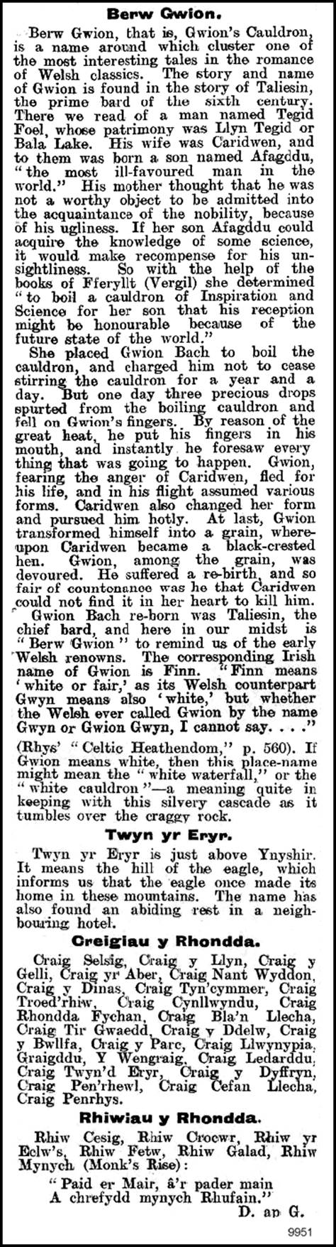
(delwedd 9951) (03 Gorffennaf 1909)
|
Berw Gwion.
Berw Gwion, that is, Gwion's Cauldron, is a name around which cluster one of
the most interesting tales in the romance of Welsh classics. The story and
name of Gwion is found in the story of Taliesin, the prime bard of the sixth
century. There we read of a man named Tegid Foel, whose patrimony was Llyn
Tegid or Bala Lake. His wife was Caridwen, and to them was born a son named
Afagddu, "the most ill-favoured man in the world." His mother
thought that he was not a worthy object to be admitted into the acquaintance
of the nobility, because of his ugliness. If her son Afagddu could acquire
the knowledge of some science, it would make recompense for his
unsightliness. So with the help of the books of Fferyllt (Vergil) she
determined "to boil a cauldron of Inspiration and Science for her son
that his reception might be honourable because of the future state of the
world."
She placed Gwion Bach to boil the cauldron, and charged him not to cease
stirring the cauldron for a year and a day. But one day three precious drops
spurted from the boiling cauldron and fell on Gwion's fingers. By reason of
the great heat, he put his fingers in his mouth, and instantly he foresaw
every thing that was going to happen. Gwion, fearing the anger of Caridwen,
fled for his life, and in his flight assumed various forms. Caridwen also
changed her form and pursued him hotly. At last, Gwion transformed himself
into a grain, whereupon Caridwen became a black-crested hen. Gwion, among the
grain, was devoured. He suffered a rebirth, and so fair of countenance was he
that Caridwen could not find it in her heart to kill him. Gwion Bach reborn
was Taliesin, the chief bard, and here in our midst is "Berw Gwion"
to remind us of the early Welsh renowns. The corresponding Irish name of
Gwion is Finn. "Finn means ‘white or fair,' as its Welsh counterpart
Gwyn means also ‘white,' but whether the Welsh ever called Gwion by the name
Gwyn or Gwion Gwyn, I cannot say. . . ."
(Rhys' “Celtic Heathendom," p. 560). If Gwion means white, then this
place-name might mean the "white waterfall," or the "white
cauldron” — a meaning quite in keeping with this silvery cascade as it
tumbles over the craggy rock.
Twyn yr Eryr.
Twyn yr Eryr is just above Ynyshir. It means the hill of the eagle, which
informs us that the eagle once made its home in these mountains. The name has
also found an abiding rest in a neighbouring hotel.
Creigiau y Rhondda.
Craig Selsig, Craig y Llyn, Craig y Gelli, Craig yr Aber, Craig Nant Wyddon,
Craig y Dinas, Craig Tyn’cymmer, Craig Troed'rhiw, Craig Cynllwyndu, Craig
Rhondda Fychan, Craig Bla'n Llecha, Craig Tir Gwaedd, Craig y Ddelw, Craig y
Bwllfa, Craig y Parc, Craig Llwynypia, Graigddu, Y Wengraig, Craig Ledarddu,
Craig Twyn'd Eryr, Craig y Dyffryn, Craig Pen'rhewl, Craig C'efan Llecha,
Craig Penrhys.
Rhiwiau y Rhondda.
Rhiw Cesig, Ririw Crocwr, Rhiw yr Eclw's, Rhiw Fetw, Rhiw Galad, Rhiw Mynych
(Monk's Rise):
"Paid er Mair, â'r pader main
A chrefydd mynych Rhufain."
D. an G.
|
|
|
|
|
(delwedd
9957) (24 Gorffennaf 1909)
|
Rhondda Leader. 24
Gorffennaf 1909.
Welsh Topics.
Rhondda Place-Names.
The Valleys and Dales of the Rhondda.
To the right and left of the main length of the Rhondda are to be found a
number of dales, glens, gaps, and valleys of varying sizes. Some have become
the habitations of men, whilst others have escaped the stir of human hives.
The latter still retain much of their wild and pristine beauty if the
traveller will only search for them.
The place-names have as much charm and interest to the philologist as the
scenes have to the natural eye of the tourist. In many cases the Valley
place-names have not yielded much fruit, and rather than attempt meanings
which are more or less fanciful, it would be best to let them rest until some
future day when the key that will unlock the mystery will be found.
Perhaps the greater number of glens are to be found at the head of the
Valley. There is Cwm Selsig, Cwm Sai Bren, and Cwm Lluest. Lower down the
Valley is to be found Cwm Ian and Cwm Gan, Cwm Parc and Cwm Dar, Cwm y Gelli
and Cwm Nant Wyddon, Cwm Fforch, Cwm Orci, Cwm Bodringallt, and Cwm George.
If the reader is not satisfied, then he may search for Cwm Cae Dafydd, Cwm
Waun Newydd, and Cwm Cesig, and if he fails to discover these, then he can
take shelter in Cwm y Werfa (the valley of the shade).
Cwm Selsig, or Blaenycwm, obtains its name from Nant Selsig which again gave
its name to Blaen Selsig - a farm now in ruins; and to Rhiw Selsig, the steep
rise which takes us out of the Rhondda into Glyncorrwg. What “Selsig” means
we cannot divine. Morien thinks it is “Cwm Syl Saig," the valley of the holy
feasting. Now there is a Gwentian word “selsig," derived from the Latin
sesica, meaning black-pudding. This fact led the late Nathan Wyn to
humorously remark: — “Wel, yn enw pob synwyr, pwy fedyddiodd hon a'r fath enw
estronol a diystyr a hwn? Gwir fod ystyr y gair yn ei berthynas a phethau
ereill yn ddigon eglur. Gair Seisnig ydyw yn arwyddo poten (pudding)."
It is very clear that the place-name can mean “pudding," and it would be
a truer conjecture that Selsig is a personal name.
Flowing into Nant Selsig are Nant-y-gwair, Nant-yr-ychin, and
Nant-Berw-Gwion.
Another difficult Valley name is Cwm-saibren, just above Treherbert Station.
In the local vernacular it is Cwmseibran, though in the list of farms it
assumes the form Cwmsaybren. Yet again, it must have a new dress in the
Ordninance [sic; = Ordinance] maps, where it is changed into Cwm-saer-pren,
and to local fancy it is Cwm-saer-bren, which is also the postal address.
Surely, it is a much-abused word. The last form of the word probably led Dafydd
Morgannwg to conclude that it meant “the valley of the wood-worker” — a very
ingenious one indeed! Yet advocates of this form may find support in other
place-names of the neighhonrhood. — to wit, Twyn Cefan Sa'r, and Cawsi Garn
Sa'r (Cawsi Garn Saer - Ordinance Map).
|
|
|
|
|
(delwedd
9958) (24 Gorffennaf 1909)
|
Others, again,
maintain that Cwmsai-bran is Cwm Rhys Bren, i.e., the valley of King Rhys,
because a field right against it is called Cae Rhys ap Tewdwr. True, the word
"bren” means king, as may be easily seen from the forms “brenin” and
"brennus." But a difficulty confronts us immediately. How came the
compound Cwm-Rhys-Bren to pass into Cwinsaibren? The local pronunciation of
the word is probably the best guide for us, and that the true word is
Cwmseibran, which, resolved into its root elements, would mean Cwm Sai Brene;
that is, the valley of a ruler named Sai. Can it be that this was the lord's
residence, and the land on the opposite slopes was his wood park (Coedca'r
Arlw'dd)?
Cwm Dar, i.e., the valley of oaks. Dar is a common place-name in Glamorgan,
as Aberdar, Cwm Dar, Darwynno, and Deri. “Derwen," the singular word, is
commoner still. The pronunciation of this word is accountable for the
spelling — dare. If the vocalic value of Gwentian monosyllabic words
containing the long “a” of other dialects be examined carefully, it will be
found that it approaches the “aa” in the bleat of a sheep, as man is maan,
tad is taad. The “a” has the same value as “a” in such English words as –
“fare," “square,” &c.
Cwm Ian, or Cwm Iaen, the valley of ice. It lies in a very shaded spot, and never
receives a ray of sun. The “ae" of monosyllabic words becomes “a” as
maen is ma'n.
Cwm Gân (the Valley of Song). “A glen on the south-west of the hill (Twyn yr
Ystrad) is called Cwm y Gân. That means, the Glen of Song; one is in doubt as
to whether it was originally Gân or Gaer, and whether the last did not refer
to the enclosure still a distinct great circle on the flat top of the hill.
The old inhabitants still call the glen, 'Cwm Nghân.’ Nghân is the Welsh
mutated form of the word Cân, a song. We learnt from aged Morgan Llywelin,
who was 92 in 1876, that in his youth an annual Mabsant was held on this
hill-top.
He said it was called Mabsant y Maendy” (Morien, p. 310).
Cwm y Werfa; the valley of shade. “Dewch i'r gwerfa," is come to the
shade. There is a place of the same name in the parish of Aberdare.
Cwm Lluest lies just above Berw Nant Gwion. “Luest” means a cottage booth.
This and other names prove that the heights of Penpych were once inhibited.
Further away on the road to Aberdare is "Pont Lluest Wen," with one
end in the parish of Ystradyfodwg and the other in the parish of Aberdare. A
contracted form of this place-name is “Llest," which is found just above
Ferndale.
|
|
|
|
|
(delwedd
9954) (02 Hydref 1909)
|
Rhondda Leader 02 Medi 1909
Welsh Topics
XV. Rhondda Place-Names.
The work of interpreting the meaning of our place-names is one which is
becoming more important in the study of words. It is the only method of
solving many features of our history, and the catena of historical trend is
incomplete without the lessons that place-names teach us. It is pleasing to
find that there are many readers who take a genuine delight in the story of
Rhondda place-names. Most of our local history can only be recovered by a
diligent and philological study of the names given to mountain and hill,
valley and dale, river and brook, and home and farm.
One certain truth they teach us is the vast richness of the vocabulary of the
Celt, not only in the number and variety of words, but also in their beauty
of poetry and form. Some reflect the aptitude of the Celtic mind to correctly
describe a geographical situation, or a physical description; others portray
their intrinsic beauty or tell us what animals frequented these parts; others
are attractive from some personal interest, and others from some warring
incident.
This is true, to a greater or lesser degree, of all classes of place-names;
and especially so of mountains, farms, and streams. The names of mountains
and streams are among the oldest we have, and go back to a great antiquity.
Their hoary age dim their meaning, and the key to unlock their mystic meaning
is only rarely found.
Perhaps one of the most interesting of our place-names are the field-names. A
glossary of field-names of the Rhondda would form most interesting reading.
Here are a few of them. It needs only time and patience to complete the list.
If any reader can supply me with the names of others, the list will be
gratefully inserted.
I. — CAEAU (FIELDS).
1. Cae fla'n tŷ, Caemawr, Yr Erw, Pant y cae, Caeau Torpych.
2. Clyncelyn.
3. Waun genol, Waun newydd, Waun went.
4. Erw pwll glo, Cae garw, Cae dan tŷ, Cae ceffyla.
5. Cae Rhys, Cae Ton, Cae Waunhelyg, Ton Waunhelyg; Gelli Cae Ton, Caegwyn,
Cae Ifan Domos, Banwan Isha, Banwan Ycha, Cae Bryn Gelli, Y Graig, Waun dan
ty`, Cae 'r hen dŷ (pronounced Ca' rhun dŷ), Ynys Rhyd Tew, Waun
Bryn Ceirw, Cae Rhyd, Cae Cwm, Waun Fain, Caeau Pentwyn.
6. Cae'r Fynwant, Cae'r Porth Cae-newydd, Cae Cefan, Cae Banal, Cae Glîshon,
Cae War Hewl, Can Gwyndu, Erw'r Bedda.
7. Waun 'r Ergyd, Yr Erw Dorwan, Cae Tonhir, Llwyniwrch, Coedcaemawr, Yr Ery
Blifiog Cae Drysiog, Y Croft, Yr Hendre.
II. — BERW A SCWD (WATERFALLS, &c.). Berw Gwion, Berw Nantgwair, Berw
Nant yr ychin; Scwd y Garrag Lwyd, Scwd y Blaenrhondda.
III. – FFYNNONAU (WELLS).
Ffynnon Bodringallt, Ffynnon Coedcae-mawr, Ffynnon Coedcae Rhondda, Ffynnon
Cwm Orci, Ffynnon Cynllwyndu, Ffynnondwym, Ffynnon Derwen Shams, Ffynnon
Fair, Ffynnon y Fro, Ffynnon Jacob, Ffynnon Las, Ffynnon Lai, Ffynnon Lluest
Wen, Ffynnon y Maendy, Ffynnon Mynyddbach, Ffynnon Pentwyn, Ffynnon Saith
Erw, Ffynnon T(y)isha, Ffynnon Ton Llwydd, Ffynnon Ton Rhys, Ffynnon Ty'r
Cwar, Ffynnon Ty Fry.
|
|
|
|
|
(delwedd 9962) (11 Rhagfyr 1909)
|
Rhondda Leader. 11 Rhagfyr 1909.
Rhondda Place Names.
XVI. Farmhouses.
Before entering upon a detailed study of the names of the many farmhouses of
the Rhondda, we will give a complete list of them as they appear in the
Parish Book.
Fforch Orchy, Ty Isaf, Ty yr Eglwys, Gelli Fawr, Ynysgoy, Ton, Maindy,
Ty'n-bedw, Glyncoly, Tila Du, Abergorchy, Glynmoch Isaf, Tynewydd, Tonllwyd,
Cwmsaybren, Blaenselsig, Tir y Felin, Ystrad Fechan, Tir Gibbon, Pen Twyn, Ty
Newydd, Bryn Gar, Nant Llecha, Ton Rhys, Castel!, Ynys Cambwll, Llwyn y Gwin,
Nant Gwin, Pencaedrain, Hendre Fawr, Y Rhyd, Bailey Glas, Gwangon Isaf,
Bryn-ton-Howell, Gwangon Ganol, Blaen Gwangon, Blaengarllich, Llydarddu,
Bwllfa, Bellifallwg (? Gellifaliog), Pentre Agil, Pentre Cegil (pron. Pentra
Cacal), Hendre Cefn Isaf, Glynmoch Isaf, Ynys Wen, Ystrad Ffurnel, Blaenrhondda,
Troedyrhiw-is-ffynon, Hendre Geulan, Cynllwyndu, Tyntila, Penrhys Isaf, Pant
Eisteddfawr (pron. Pantsteddfa), Penygraig, Hendre Wen, Pencelli, Rhondda
Fechan, Mardy, Penrhys Isaf, Pentre, Cwmdare, Ynysfeio, Tila Fforest, Parc
lsaf, Bodryngallt, Blaen Clydach, Pwll yr Hebog Tynewydd, Coedcae Arlwydd,
Parc Uchaf, Tyla Coch, Nant Dyrus. Ynys y Graig, Brithweunydd Uchaf,
Brithweunydd lsaf, Tir Will Bach, Hendrefadog, Dyffryn Sarfwch, Melin yr Hom,
Gelli Galed, Ffynon Dwym, Nantwyddon, Carn Celyn, Penbont Rhondda,
Troedyrhiw, Ynyshir, Llwynypia, Glyn Cornel,_Penbont Clydach, Tir y Pandy,
Werfa, Ynysonos, Penrhiw.
Many of these old homesteads are now no more, and only a few stones remain to
mark their site. What a tale these could unfold were the old stones to speak;
what changes they have witnessed; and what tales of myth and legend were once
told within the walls. Obscure and of mean pretence, they were once of note
and importance in the sight of the few hundreds that inhabited the Rhondda.
Several were small tenements attached to the larger farms. Many of these
tenements are either prefixed or affixed by "tŷ." Commencing
at the upper end of the Valley there is "Yr Henry" (on the old
Parish Road), near which is an old quarry, "Cwar Henry." Just below
is Ty’n waun" — "the house in the meadow," and over against
this, but higher up the Valley, is “Ty'n wern" — "the house of the
alder trees." In the Blaencwm Valley are Ty Isha
(pron. T'isha) and Tydraw, and a little lower down the valley, Tynewydd,
the residence of the old Rhondda veteran, Alderman William Morgan.
Then there are Ty yr Eglwys (pron. Ty'r Eclws), Ty'nbetw, Ty Fry, Ty'n Graig
below Craig y Gelli Y Maendy, Ty'ntila on the Penrhys Road, Y Pandy and
Ty-ar-Twyn just behind De Winton Hotel, and Ty Dyrmig.
It is impossible to explain all the list of farmhouses; so we shall confine
our remarks to a few of the more interesting ones.
LEDAR-DDU.
The above spelling may appear strange because of the more accustomed form
found on the pillar stones at the entrance of the cemetery —
“Lledr-ddu." In the Parish Book it is written “Llydar-ddu." These
two forms are at variance with the colloquial rendering, “Ledar-ddu."
“Lledr-ddu” is due to a false analogy, because it was supposed to mean “the
black slope," and that "lledr” was akin to “llethr," a slope.
If it is “Lledr” or “Llydar," whence the "ll"? The “ll"
is entirely foreign.
The word “ledr," or the dialectal form "ledar" has its
correspondent in "Cledr" or "Cletar," as in "Nant
Cletar," and “Gwaun Cletar," near Caerphilly, and in “Glyder” of
North Wales. It is a very common thing in the phonetics of the Welsh dialects
to find that in one part of the country there may be a prefixed "c” or
"g," whilst in another part it is absent, as giar and iar, gallt and
allt, arth and garth, &c. So here, “ledar” and “cletar." The
"t” of the latter word is the accentuated form so peculiar to the
Gvtentian dialect, and “d” and “t” are easily interchanged.
|
|
|
|
|
(delwedd 9963) (11 Rhagfyr 1909)
|
The English word for
“clear” or “ledr” is “a stake." "Cae gledr” is a field enclosed by
stakes, or palisades. "Gwaun Cletar” is the meadow enclosed by stakes.
(See "Cymru” for October, 1909, p, 196). “Ledar-ddu” means the dark
field or a field of dark soil enclosed by palisades or stakes.
The colloquial form is a far truer guide than any coined form. So that in the
face of the above considerations we are more inclined to “Ledar-ddu"
than to “Llethr-ddu” or "Lledr-ddu." If the “II” was changed to
"l," then there would be nothing in this word to offend our eyes,
for the “a” of “ledar” is nothing more than an intrusive vowel for the sake
of easing the sound. (Cf. ofon and ofan for ofn ochor for ochr, amal for aml,
Ilwybyr for llwybr, etc.).
Pencelli, the chief of the hazel groves. The correct form is Pencelli, and
not Pengelli. Pen governs the radical “c." Dafydd ap Gwilym used the
form “celli," as in the following couplet: —
"Nid oes babell mewn celli
Na man fal bu gynt i mi.”
Celli-wig, the forest of hazels, was the name of King Arthur's Palace.
TY DYRMIG.
Tŷ Dyrmig was an old-fashioned little dwelling which once stood near the
present site of the Thistle Hotel. The road which ran past was Hewl Ddyrmig,
which gave its name to the old house and the rushing mountain torrent. Nathan
Wyn, in his account of the Rhondda, tells us that the parish paid, in 1747,
the sum of two shillings for repairing Hewl Ddyrmig, and again that in 1752
it paid sixpence “am wella canllaw pont y Dddirmyg."
This place-name is pronounced in the patois as “Ddyrmig," though it is
oftenest spelt “Ddirmyg," which has led people to believe that it means
rejected, despised. The word "dyrmig" is derived from the English
“turnpike.” “N” and “p” are assimilated in Welsh into "mp," as “yn
pen” becomes “ymhen." Compare again cymhell or cymell from Latin
compello, and cymharu from Latin, comparo. So that “m” of Dyrmig resolves
itself originally into “mp” or "np," and thus we get at either
“dyrpig" or “dyrnpig." It may be objected, though, that the
Cymricised form is generally “tyrpig," or “tyrnpig," or
“trympig." This objection is easily met, for in the word “Dyrmig"
we have the word having run through its whole philological course turnpike,
tyrnpig, tyrmig, dyrmig.
Keeping these facts before us we arrive at an interesting conclusion that the
road through LIwynypia was the highway from
|
|
|
|
|
(delwedd 9964) (11 Rhagfyr 1909)
|
Llantrisant on
through the Valley. This was the route along which the tourists of the
eighteenth century passed through the valley. "Hewl Ddyrmig” was
maintained by the parish, and possibly later research will yield us the fact
that there was situated here an old toll-gate.
CLUNGWYN OR CLYNGWYN.
This pretty place-name is a compound of “clyn" and “gwyn." It is
rendered in two ways, either “Clyngwyn” or “Clungwyn," and the latter is
the more correct form. The word “clun” is found in two place-names in the
Rhondda — (1) the farmhouse (Clungwyn) situated at the head of a meadow at
the foot of Penpych, and (2) Clundelyn, a field right opposite to it, just in
front of the Dunraven Schools. “Clun” is not a very common word, though it is
found in a few place-names, as Clungwyn in Mountain Ash, Pont-y-Clun (or
Pont-y-clown) near Llantrisant, ClunlIwytrho near Rhigos, Clun Forest in
Radnor, Clunbury and Clungunfordd in Salop. It is an old British word,
meaning “meadow." Other forms of the word are “cluain,"
“cloon," and "cloune." The word “cloune" appears in the
“Survey of the Clare's Estate” (1314). See “Edward II. in Glamorgan,"
App. E., p. xxiii.).
HENDRE.
There are several farms which bear this resignation. The “hendre" or
“hen-dref” was the winter abode, in contrast to the “hafod” or summer abode
(q.v. "Rhondda Leader” for February 6th, 1909).
(a) Hendre Fawr.
(b) Hendre Cefan Isha.
(c) Hendre Geulans, [?] the hendre on the hollow bank of a river. It was
situated at the foot of Mynydd T'isha, Blaencwm. The southern boundary runs
along the summit of Graig-y-Ddelw.
(d) Hendre-wen.
(e) Hendre-fadog. What Madoc was this after whom the farm was named?
(f) Hendre-Gwilym, the farmstead from which Trewilliam has derived its name.
(g) Hendre-cafan. The word “cafan” has been a puzzle to many who have
attempted to explain it. Some have even foolishly suggested it to mean
“trough," as in “cafan moch." "Cafan” is a diminutive
"caf," which, resolved into its earliest form, would be “cab,"
which is found in the modern Welsh, and also the Pre-Norman form,
“caban." The “b” is also preserved in its English equivalent,
“cabin," and in certain Welsh place-names as “Twyn Caban," near
Penpych. (Cf. M.E. caban). The caban was “a booth made with rods set in the
ground and tied at the top” (Skeate).
It is interesting to note that there is another place-name in Glamorgan where
the “b” of the earlier form has passed into the “f” of to-day: — Nant-carfan is
the old form of Nant-carfan, “o Ian Garban” (Welsh MSS. ii., 33), and “Llan
Garban” (Myf. Arch.).
(h) Hendre-gron, an old homestead once situated just above Treorchy Cemetery.
GLYNCOLI OR GLYNCOLY.
Glyn, a dell or glen. “Coli” is the plural of “col," a point, peak, or
end.
BLAENLLECHA.
This is one of the most interesting of the Rhondda place-names, and one which
has suffered badly in thousands of would-be philologists. “Llech," as
found in the two words, Blaenllecha and Nantllecha, is a cognate form of the
Welsh word “Ilwch," a pool or lake. It is akin to the Gaelic or Irish
“loch" and "lough." It is found in a few place-names as
“Amlwch," “Llechryd," “Llyn-cwm-llwch” in Brecknock Beacons,
“Cas-Ilwchwr”, and Tal-y-llychau.”
“Except in Amlwch it appears to be confined to Dyfed and Gwent.”
(Translations of Guild of Graduates, 1908).
That “llech” refers to a pool or lake, and not to "stone” as some
suppose, is supported by the fact that there exists in Rhondda Fechan the
famous "Damsels' Pool” — “Llyn y Forwyn" or "Llyn
Elferch." The legend of “Llyn y Forwyn” is old and very similar to the
tale of “Craig y Forwyn." If any reader wishes to read it in extenso, he
may see it in Rhys's “Celtic Folklore"; but. with the permission of the
Editor, we may continue this column by discussing the folk-lore of the
Rhondda. This series of articles on the Rhondda Place-Names are now
concluded. It is to be hoped that they have enabled the youths of the Rhondda
to see what a vast mine of unwritten literature is to be found in the study
of our place-names. (Conclusion).
|
|
|
|